
Stations
The Pony Express Used Over 190 Stations
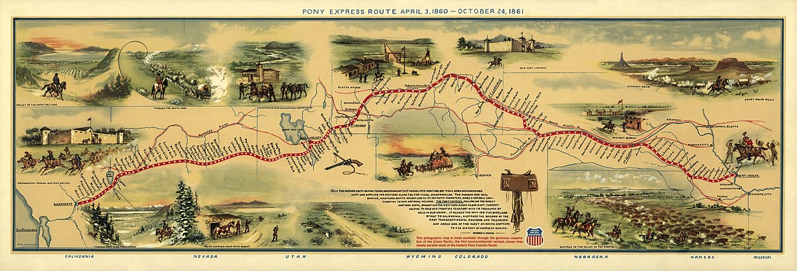
Pony stations were generally located between 5 to 20 miles apart. The terrain and its effect on horse travel determined the number and the distance between stations. Stations that already existed for the stagecoach line were also used for “The Pony”. Ranches in the area were used, if the location fit. New stations were then added where needed. Building materials generally consisted of sod on the plains, timber in the forested areas, stone or adobe on the deserts or dugouts carved in a hillside and roofed with freighted-in timber. (FYI: “Ranches”, or Road Ranches, in Pony Express days, were watering spots/little supply stores/emigrant trail hostels/stopover places or the like, not like the big-acreage cattle/horse holdings, as we know today. They may have simply been someone’s house who was willing to barter or sell water, food and/or goods to travelers.)
At each relay (swing) station, riders would exchange their tired horse for a fresh one. Home stations (usually the older stage stations) had horses, plus housed the riders between their trips. There were about 25 home stations along the route. This arrangement allowed the mail to speed across the country in record time. Each rider rode about 75-100 miles per shift, changing horses 5-8 times or so. Two minutes was allotted for horse and mochila exchanges at each station.
Station Keepers and Stock Tenders
The Pony Express Riders were brave and to be admired. However, their success would have been impossible without the station keepers and stock tenders. Theirs was not an easy life. It was isolated, primitive and dangerous. They were truly unsung heroes. Stations were attacked and the horses stolen, the stations burned and keepers killed, especially during the Pauite Indian War starting in May 1860. Russell, Majors and Waddell actually suspended delivery between Carson City and Salt Lake City for about a month in June 1860.
Stations
The Pony Express Trail route went through a number of changes over time, to adjust to ground conditions, seasonal weather or other circumstances. Maximum efficiency was a priority. Not all the stations listed were used all of the time. Stations were added or deleted when necessary. The station listings are in east-to-west order, using present state boundaries. (FYI: Only two states of the Pony Express Trail actually existed at the time: Missouri and California. The areas of what are now KS, NE, CO, WY, UT & NV were still “territorial lands”.) Station names often varied between authors and historians, and many stations had different names at any given time. Some are based on location or station master names, distances from or to, etc. Some variations simply appear to be transcription errors. These lists have tried to include all names that are found in the historic literature.
Click on the State Name below for the listing of stations located there:
| Number of | |||
| Station Listings | Miles of Trail | ||
Missouri |
3 | 2 | |
“Kansas” |
13 | 151 | |
“Nebraska” |
38 | 565 | |
“Colorado” |
2 | 27 | |
“Wyoming” |
43 | 489 | |
“Utah” |
27 | 263 | |
“Nevada” |
47 | 417 | |
California |
24 | 87 | |
TOTALS |
197 | 1966 Miles |
If the below map does not display for you – please click this Link