Nebraska Stations
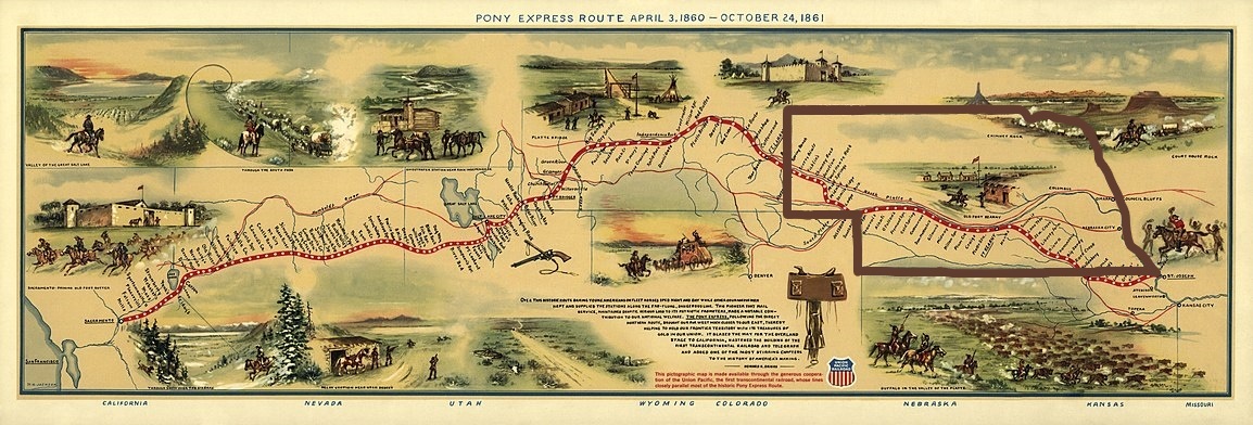
Much of the Pony Express Trail through Nebraska used the natural road created by the Platte River Valley, just like the schooners of the Oregon Trail.
- Rock House / Rockhouse / Caldwell / Otoe
- Rock Creek & Lodi P.O. / Turkey Creek / Pawnee / Elkhorn
- Virginia City / Graysons / Whiskey Run / Lone Tree
- (H) Big Sandy / Patterson’s / Daniel Ranch / Ed Farrell Ranch
- Millersville / Thompson’s
- Kiowa
- Oak Grove / Comstock’s / Little Blue
- (H) Liberty Farm
- Spring Ranch / Pawnee Ranch / Lone Tree
- (H) Thirty-Two Mile Creek / Thirty-Two Mile / Dinner / Elm Creek
- Sand Hill / Summit / Fairfield / Water Hole / Gills
- (H) Kearney / Kearny / Valley City / Omaha Junction / Dogtown / Junction City / Hinshaw’s Ranch / Hooks
- Dobytown (the station was 2 miles west of Fort Kearny)
- Fort Kearney / Fort Kearny (the actual XP station was not inside the garrison)
- Platt’s / Platte / Seventeen Mile
- Garden / Shakespear / Craig’s / Sydenham’s / Biddleman Ranch
- Plum Creek
- Willow Island / Willow Bend / Willow Springs / Spread Eagle (the actual station is now located in the Cozad city park)
- (H) Midway / Heavy Timber / Coldwater Ranch / Pat Mullaly’s Ranch / Lower 96 Ranch / Smith’s East Ranch (still standing at its original site south of Gothenburg)
- Gilman’s
- Machette’s / Upper 96 Ranch / Dan Trout’s / Joe Bower’s / Broken Ranch (the actual station is now located in the Gothenburg city park)
- Cottonwood Springs / McDonald’s Ranch (near Fort Cottonwood / Fort McPherson)
- Cold Springs / Box Elder
- (H) Fremont Springs / Buffalo Ranch
- Danseys / Dorsey’s / Half Way House / O’Fallon’s Bluff / Elkhorn
- Alkali Lake / Pike’s Peak
- Gill’s / Sand Hill
- (H) Diamond Springs
- (FYI: Beauvais Ranch / Lower California Crossing / Brule Crossing / Ash Hollow Crossing / Fort Laramie Crossing / California Crossing — This stage station is only 2 miles west of Diamond Springs. It was important for those traveling on the Oregon Trail, but probably was not a Pony Express Station, as it was so close to Diamond Springs. It was here that settlers crossed the South Platte River and headed north, over California Hill and through Ash Hollow, up to the North Platte River Valley. The Pony Express Route continued along the South Platte, on to Julesburg.)
- From Diamond Springs Station, the Pony traveled into
-
Colorado
- and then back into the Nebraska Panhandle..
- Nine Mile / Lodge Pole
- Pole Creek No. 2 / Farrell Ranch
- Pole Creek No. 3 / Rouliette Ranch / Pringle Ranch
- Midway / Government Well / 32 Mile Ridge / 30 Mile Ridge
- (H) Mud Springs
- Court House / Courthouse Rock / Pumpkinseed Creek / Pumpkin Creek (this cabin was moved to Pioneer Village at Minden in 1955)
- Chimney Rock / Facus Springs
- Ficklin’s Springs / Robidoux’s Fort / Ficklin’s / Ash Hollow
- (H) Scott’s Bluff / Fort Mitchell
- Horse Creek
LEGEND:
(H) = Home Station (some of these changed over time, as needed)
Bold = Station Name on the original U.S. Senate Executive Document, 46th Congress, 3rd Session, I, No. 21 p.7-8 “Contract with Overland Mail Co” “Route 10773”
Italics = Station Name listed on the 2010 Map prepared by the National Pony Express Association and produced and printed by the National Parks Service to celebrate the Pony Express Sesquicentennial.